India’s southwest monsoon has entered a powerful and highly active phase, with satellite images revealing two enormous weather systems developing simultaneously on either side of the country. Images captured by the Indian Space Research Organisation’s INSAT-3DR weather satellite show massive cloud formations over the Arabian Sea and the Bay of Bengal, helping explain the intense rainfall affecting Maharashtra, West Bengal and several other regions.
The dramatic satellite view has drawn attention to the scale of the ongoing monsoon activity. One large cloud mass is positioned over the Arabian Sea and influencing India’s western coast, while another major system is active around the Bay of Bengal and eastern India. Together, these systems are feeding moisture into different parts of the country and contributing to widespread rainfall.
The satellite imagery comes at a time when the southwest monsoon is showing strong activity across India. The India Meteorological Department has indicated that active monsoon conditions are expected to continue, with several regions facing the possibility of heavy to very heavy rainfall. The development has increased the importance of weather monitoring, disaster preparedness and timely public alerts during one of the most intense phases of the 2026 monsoon season.
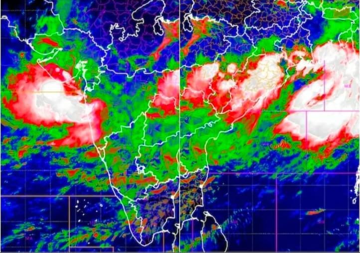
INSAT-3DR Captures Massive Cloud Systems Over India
The images were captured by INSAT-3DR, one of India’s important meteorological satellites used for monitoring the atmosphere and observing major weather developments. From its position in space, the satellite continuously provides information about cloud formations, moisture, temperature and changing weather systems.
The latest images show towering and widespread cloud masses stretching across large areas. On India’s western side, a powerful system over the Arabian Sea is supporting intense rain over Maharashtra and nearby regions. On the eastern side, a major system connected with the Bay of Bengal is influencing rainfall over West Bengal and other parts of eastern and central India.
Satellite monitoring is especially important during the monsoon because weather systems can strengthen, move and interact with surrounding atmospheric conditions. Continuous observation allows meteorologists to study the development of cloud clusters and identify areas where rainfall may become particularly intense.
The two giant systems visible in the imagery demonstrate the enormous geographical scale of India’s monsoon. Unlike a local thunderstorm affecting a limited area, large monsoon systems can influence weather across several states and continue to produce rainfall for multiple days.
Maharashtra Faces Intense Rainfall from Arabian Sea System
Maharashtra has been among the regions experiencing significant rainfall as the Arabian Sea branch of the monsoon remains highly active. Moisture-laden winds from the sea are moving towards the western coast, supporting the formation of thick clouds and repeated spells of rain.
Coastal Maharashtra is particularly vulnerable during intense monsoon phases. Mumbai and surrounding areas often experience waterlogging, transport disruption and traffic problems when heavy rainfall continues for extended periods. Low-lying areas can face additional challenges when drainage systems are unable to handle large volumes of water within a short time.
The satellite imagery helps illustrate why rainfall has been so intense. A massive concentration of clouds over the Arabian Sea is supplying moisture to the western part of the country. As these moisture-rich winds move inland, geographical features such as the Western Ghats can further enhance rainfall in some areas.
Recent reports have shown the exceptional intensity of the season in Mumbai, where rainfall totals had already reached a substantial share of the city’s normal seasonal average by early July. This underlines the strength of the current monsoon phase and the need for continued caution in flood-prone areas.
Bay of Bengal System Drives Rainfall in Eastern India
At the same time, another enormous monsoon system over the Bay of Bengal is affecting eastern India. West Bengal has been one of the major areas under the influence of this cloud mass, with heavy rainfall reported in parts of the region.
The Bay of Bengal plays a major role in India’s monsoon weather. Low-pressure areas developing over the region can draw in large quantities of moisture and move towards eastern, central and northern India. Depending on their strength and movement, these systems can produce widespread rainfall across several states.
The latest weather situation is particularly significant because the Arabian Sea and Bay of Bengal systems are active at the same time. This simultaneous activity is helping maintain a broad zone of monsoon rainfall across the country.
According to the India Meteorological Department, a well-marked low-pressure area over the northwest Bay of Bengal was expected to keep the monsoon active over central parts of India for several days. The official forecast also warned of isolated extremely heavy rainfall in some regions, showing that the current weather pattern is not limited to ordinary seasonal showers.
Why Two Active Monsoon Systems Matter
The presence of two large monsoon systems is important because it can lead to widespread rainfall across different geographical regions at the same time. Western India may receive moisture from the Arabian Sea, while eastern and central India can be affected by systems originating over the Bay of Bengal.
When monsoon conditions remain active for several days, the risk of disruption can increase. Soil may become saturated, rivers and streams can rise, and urban areas may experience repeated waterlogging. In hilly regions, persistent heavy rainfall can also increase the danger of landslides.
For agriculture, the situation presents both opportunities and challenges. Good monsoon rainfall is essential for farming, reservoirs and groundwater recharge. Millions of farmers depend on seasonal rain for sowing and crop development. However, excessive rainfall can damage standing crops, flood agricultural land and delay farm operations.
Businesses are also closely affected by intense monsoon activity. Transport companies, construction firms, retailers, logistics providers and small businesses can face operational delays when roads are flooded or supply chains are interrupted. At the same time, strong rainfall can improve prospects for agriculture-linked sectors when it remains well distributed and does not cause major damage.
IMD Forecast Signals Continued Active Monsoon Conditions
The India Meteorological Department has continued to monitor the evolving situation and issue forecasts for affected regions. Active monsoon conditions have been expected to persist across central parts of the country, while heavy to extremely heavy rainfall alerts have covered multiple states.
The current weather pattern shows why official forecasts should be followed closely. Rainfall intensity can vary significantly from one district to another, and conditions may change quickly as weather systems move.
Residents in vulnerable areas should pay attention to local warnings, avoid unnecessary travel through flooded roads and remain cautious near rivers, drains and waterlogged zones. Businesses and local authorities may also need to prepare for temporary disruption if intense rainfall continues.
The satellite images offer a striking view of the natural forces shaping India’s weather. They also demonstrate the growing importance of space technology in forecasting, emergency planning and public safety. With INSAT-3DR continuously observing the atmosphere, meteorologists can track major systems and improve understanding of changing monsoon conditions.
As the 2026 monsoon continues, the twin giant cloud systems over the Arabian Sea and Bay of Bengal have become a powerful visual representation of the season’s intensity. The coming days will remain important for Maharashtra, West Bengal and other affected regions as weather agencies continue to monitor rainfall and issue updates.
For more updates regarding business-related news, follow News Now Nation at newsnownation.com.
